Products contained in this archive have reached the end of their useful lifespan (EOL) and will soon be moved to our Legacy Archive. These products are currently supported, but sales for all items is no longer available. Please contact us for more information on any archived product.
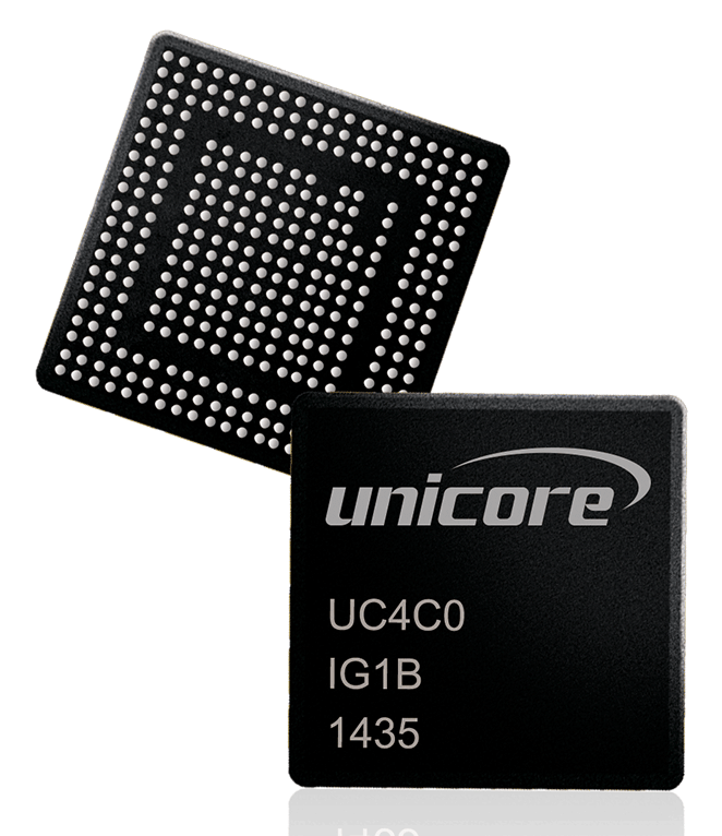
Nebulas-II (UC4C0) is our previous generation multi system multi core high precision GNSS SoC
The high precision Nebulas-II SoC has a 55nm low power design and supports up to 12 digital intermediate frequency or 8 analog intermediate frequency signals, which can track 12 navigation signals with 432 channel. UC4C0 supports single system independent positioning and full GNSS (GPS, Glonass, Galileo, Beidou and QZSS) multi-system interoperation. With a built-in advanced anti-jamming module, UC4C0 provides high quality observation, position, and velocity data under difficult electromagnetic environments, providing users with high reliability and high performance.
The Nebulas-II SoC is integrated and available via Unicore’s High Precision boards and modules.
Applications
-
Over the years, navigation, and positioning, along with audio, video, camera, and wireless communication (cellular communication, Wi-Fi, Bluetooth) has become integral features of tablets and mobile devices. Apart from communications and multi-media capabilities, tablets
-
The use of robots is spreading in day-to-day life. From remote delivery vehicles to remote inspection services to automated lawn mowing or line painting robots, the use of robotic machines is growing. Precise positioning and heading play an important role when it comes to the
Features
-
Core Features
- UniTrack: Universal multi-channel, multi-frequency tracking engine
- JamShield: High-performance multi frequency anti-jamming technology
- Instant Heading: Rapid heading technology
- RTK Enhanced: multi-system, multi-frequency RTK technology
- 432 channels: all systems, all frequencies
- Millimeter level measurement accuracy
- Built-in 4 dual-channel high-speed ADC, simplified RF design
Performance
Channels
432Satellite Systems & Frequencies
BDS: B1/B2/B3
GPS: L1/L2C/L2P(Y)/L5
GLONASS: L1/L2
GALILEO: E1/E5a/E5b
QZSS: 1 CA L2C L5
SBASSingle Point Positioning Accuracy
1.5mDGNSS Positioning Accuracy
0.4mRTK Positioning accuracy
1cm + 1ppmHeading Accuracy (Dual Antenna Input only)
N/APower Consumption
1.5W @ 12 frequencies (Board Level)
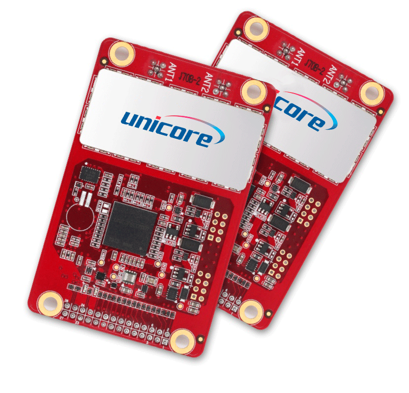
UB482 is a new generation positioning and heading board based on the Nebulas-II high-performance high-precision GNSS SoC.
The High Precision UB482 is a multi-system, multi-frequency high-precision heading board supporting GPS L1/L2, GLONASS L1/L2, Galileo E1/E5b, QZSS L1/L2 and BDS B1/B2. The classic-size UB482 supports network navigation network connectivity and includes inertial navigation. It is widely used in drones and robotic applications, marine navigation, antenna pointing and industrial applications such as agricultural guidance and machine control solutions.
Applications
-
The growth of automation in agricultural production has greatly raised productivity and changed the traditional farm into an efficient state-of-the-art operation. The use of GNSS enables agricultural machinery to be precisely positioned in the field.
-
GNSS technology not only provides high precision positioning thru techniques such as RTK, it is ideal as a heading or orientation system as well. By merging two GNSS RF components onto a single board or module and combining with other associated components,
Features
-
Core Features
- Industry standard 46 x 71 mm compact board with standard PIN interface
- Multi-system, multi-frequency high-precision RTK and Heading
- Supports GPS, Glonass, Galileo, Beidou and QZSS
- Simultaneous output of heading and positioning at output rates up to 20 Hz
- RTK reacquisition time of less than 1 second
- Based on multi-system, multi-frequency high-performance Nebulas-II GNSS SoC
- Dual-antenna input
- Advanced multi-path mitigation technology
- 1PPS
- On-board MEMS integrated navigation
-
Customized Services
- A Complete and Reliable Heading and positioning Solution
- All-Constellation Multi-Frequency
- 0.2°/1m baseline Dual Antenna Heading
- Centimeter level RTK
- Evaluation Kit and Interface Software available to help assist the integration
-
Core Technology
- Instant RTK initialization and fast RTK convergence
- "Instant Heading"
- "RTK KEEP" Adaptive recognition of RTCM
- Adaptive recognition of RTCM
- Advanced multi-path mitigation technology
Performance
Channels
432 channels, based on Nebulas-II GNSS SoCSatellite Systems & Frequencies
GPS L1 / L2 L2P(Y)
BDS B1I / B2I
GLONASS L1 / L2
Galileo E1 / E5b
QZSS L1 / L2Single Point Positioning Accuracy
Horizontal:1.5m
Vertical:2.5mDGNSS Positioning Accuracy
Horizontal:0.4m
Vertical:0.8mRTK Positioning accuracy
Horizontal:1cm + 1ppm
Vertical:1.5cm + 1ppmHeading Accuracy (Dual Antenna Input only)
0.1 degree @ 1m baselinePower Consumption
2.4W(typical)Size / Dimensions
46 × 71 × 9.5 mm
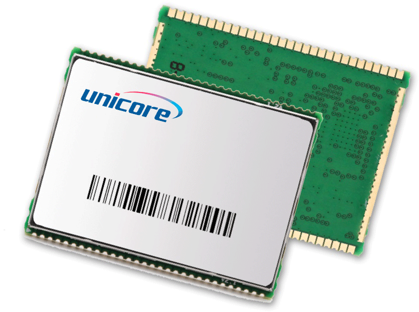
UM482 is the smallest high-precision positioning and heading module in the world.
Based on Nebulas-II SoC, the high precision UM482 tracks all the key satellite signals, including GPS L1/L2, GLONASS L1/L2, Galileo E1/E5b, QZSS L1/L2 and BDS B1/B2. The module is designed for use in Robots, UAV/UAS products, Antenna Pointing equipment, Navigation systems, GNSS Compass’ and any product requiring accurate and reliable heading and positioning.
Applications
-
UAV’s have been widely used in aerial photography, electrical, pipeline and facility inspections, agricultural mapping / inspection, aerial surveillance as well as for film and home entertainment purposes. Flight control systems have a significant impact on the stability, reliability,
-
The growth of automation in agricultural production has greatly raised productivity and changed the traditional farm into an efficient state-of-the-art operation. The use of GNSS enables agricultural machinery to be precisely positioned in the field.
-
GNSS technology not only provides high precision positioning thru techniques such as RTK, it is ideal as a heading or orientation system as well. By merging two GNSS RF components onto a single board or module and combining with other associated components,
-
An important part of strategic emerging industries, intelligent driving is a typical application of the combination of industrial revolution and artificial intelligence and will be an important technology in the elimination of traffic congestion in the coming years, improving
Features
-
Core Features
- 30 x 40mm size, SMD packaging
- Multi-system, multi-frequency high-precision RTK and Heading
- Supports GPS, Glonass, Galileo, Beidou and QZSS
- Simultaneous output of heading and positioning at output rates up to 20 Hz
- RTK reacquisition time of less than 1 second
- Based on multi-system, multi-frequency high-performance Nebulas-II GNSS SoC
- Dual-antenna input
- Advanced multi-path mitigation technology
- 1PPS
- On-board MEMS integrated navigation
-
Customized Services
- Smallest Heading Solution
- Compact SMD packaging
- All-Constellation Multi-Frequency
- 0.2°/1m baseline Dual Antenna Heading
- Centimeter level RTK
- Evaluation Kit and Interface Software available to help assist the integration
-
Core Technology
- Instant RTK initialization and fast RTK convergence
- "Instant Heading" Technology
- "RTK KEEP" Technology
- Adaptive recognition of RTCM
Performance
Channels
432 channels, based on Nebulas-II GNSS SoCSatellite Systems & Frequencies
GPS L1 / L2 L2P(Y)
BDS B1I / B2I
GLONASS L1 / L2
Galileo E1 / E5b
QZSS L1 / L2Single Point Positioning Accuracy
Horizontal:1.5m
Vertical:2.5mDGNSS Positioning Accuracy
Horizontal:0.4m
Vertical:0.8mRTK Positioning accuracy
Horizontal:1cm + 1ppm
Vertical:1.5cm + 1ppmHeading Accuracy (Dual Antenna Input only)
0.1 degree @ 1m baselinePower Consumption
2.4W(typical)Size / Dimensions
30 × 40 × 4 mm
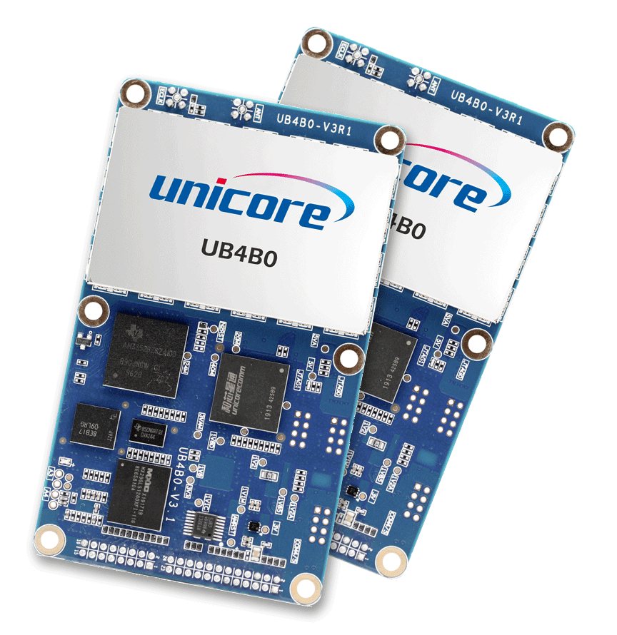
UB4B0 is an all-system GNSS high-precision board based on the Nebulas-II high-performance GNSS SoC.
The UB4B0 supports GPS, Glonass, Galileo, Beidou and QZSS satellite navigation systems. The board adopts triple-frequency RTK technology and can be used for high-precision positioning, surveying, Ground-based augmentation Systems and any application requiring high precision.
Applications
-
Robust and reliable positioning is a cornerstone of Unicore Communications product offering. Surveying and Mapping applications require a quick yet reliable and accurate solution. Unicore products are widely used by Survey instrument manufactures for these reasons.
Features
-
Core Features
- 432 channels
- Supports GPS, Glonass, Galileo, Beidou and QZSS all-constellation multi-frequency
- Advanced multi-path mitigation technology and low elevation tracking technology
- Millimeter-level carrier phase and centimeter-level pseudo range measurement
- RTK: 1cm +1ppm(H); 1.5cm+1ppm(V)
- Interfaces include Serial port, Ethernet port, 1PPS, External clock and Odometer
-
Customized Services
- Ideal for Continuous Operating Reference Stations and all precision RTK applications
- Stable and reliable
- All-Constellation Multi-Frequency
- Evaluation Kit and Interface Software available to help assist the integration
-
Core Technology
- High Precision Baseband Processing Engine
- Fast Carrier Phase Polarity Determination
- Multipath Interference Detection and Mitigation
Performance
Channels
432 channels, based on Nebulas-II GNSS SoCSatellite Systems & Frequencies
GPS L1/L2C/L2P(Y)/L5
BDS B1I / B2I /B3I / B1C / B2a / B2b*
GLONASS L1 / L2
Galileo E1 / E5b / E5a
QZSS L1 / L2 / L5Single Point Positioning Accuracy
Horizontal:1.5m
Vertical:2.5mDGNSS Positioning Accuracy
Horizontal:0.4m
Vertical:0.8mRTK Positioning accuracy
Horizontal:1cm + 1ppm
Vertical:1.5cm + 1ppmHeading Accuracy (Dual Antenna Input only)
N/APower Consumption
2.8 W (Typical)Size / Dimensions
100 x 60 x 11.4 mm
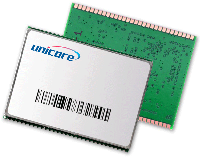
UM4B0 is a compact high precision RTK module based on the high-performance high-precision Nebulas-II SoC.
The UM4B0 can track all current visible GNSS satellite signals, including GPS. Glonass, Galileo, Beidou and QZSS. Target application fields include Robots, GIS, UAV/UAS, and any application requiring high-precision and reliable RTK positioning.
Applications
-
UAV’s have been widely used in aerial photography, electrical, pipeline and facility inspections, agricultural mapping / inspection, aerial surveillance as well as for film and home entertainment purposes. Flight control systems have a significant impact on the stability, reliability,
-
The use of robots is spreading in day-to-day life. From remote delivery vehicles to remote inspection services to automated lawn mowing or line painting robots, the use of robotic machines is growing. Precise positioning and heading play an important role when it comes to the
-
Robust and reliable positioning is a cornerstone of Unicore Communications product offering. Surveying and Mapping applications require a quick yet reliable and accurate solution. Unicore products are widely used by Survey instrument manufactures for these reasons.
Features
-
Core Features
- 30 x 40 mm, SMD packaging
- Supports GPS, BDS, GLONASS, Galileo and QZSS all-constellation multi-frequency
- RTK: 1cm +1ppm(H); 1.5cm+1ppm(V)
- Up to 20Hz Low-latency output of positioning
- Supports advanced multi-path resistance technology and low-elevation tracking technology
-
Customized Services
- Great performance in small footprint sizes
- Compact SMD packaging
- All-Constellation Multi-Frequency
- Evaluation Kit and Interface Software available to help assist the integration
-
Core Technology
- Advanced RTK technology
- Better than 1s RTK reacquisition
- "RTK KEEP" Technology
- Adaptive recognition of RTCM
Performance
Channels
432 channels, based on Nebulas-II GNSS SoCSatellite Systems & Frequencies
GPS : L1 / L2 L2P(Y)/ L5
BDS : B1I / B2I / B3I / B1C / B2a
GLONASS L1 / L2
Galileo E1 / E5b
QZSS L1 / L2 / L5Single Point Positioning Accuracy
Horizontal:1.5m
Vertical:2.5mDGNSS Positioning Accuracy
Horizontal:0.4m
Vertical:0.8mRTK Positioning accuracy
Horizontal:1cm + 1ppm
Vertical:1.5cm + 1ppmHeading Accuracy (Dual Antenna Input only)
N/APower Consumption
1.8 W (typical)Size / Dimensions
30 × 40 × 4 mm
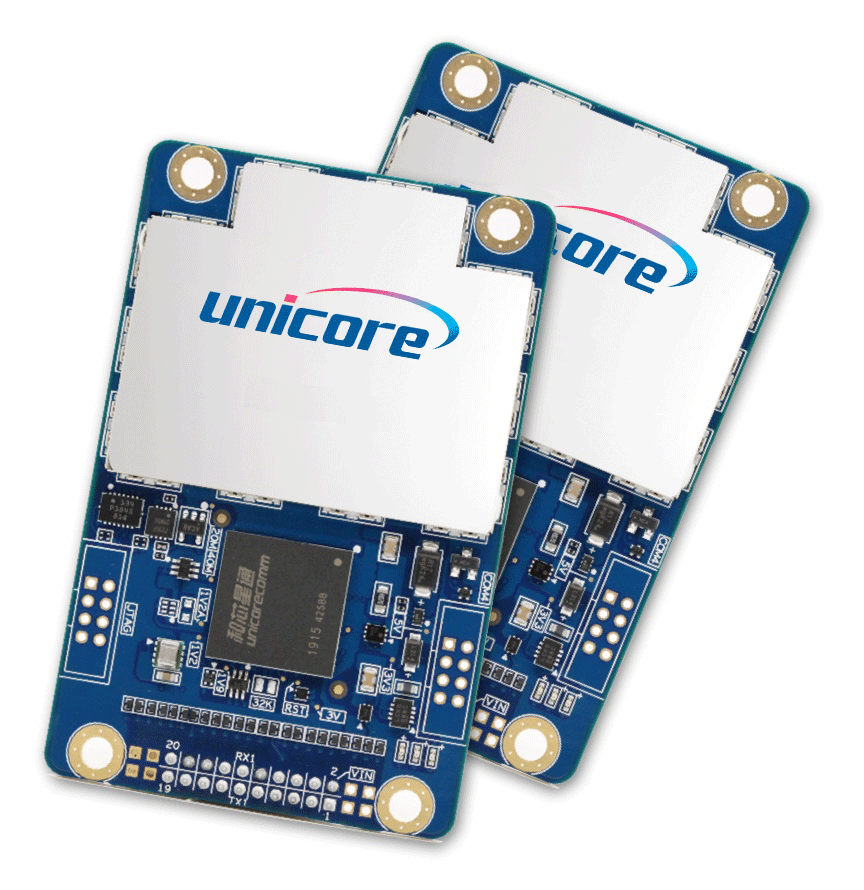
UB4B0M is a compact multi-system GNSS high-precision board based on the Nebulas-II high-performance GNSS SoC.
Suitable for high precision positioning and navigation, the UB4B0M supports GPS, Glonass, Galileo, Beidou and QZSS satellite navigation systems. The UB4B0M delivers low power consumption, millimetre-level carrier phase observations, centimeter-level RTK positioning and supports multi-path mitigation.
Applications
-
The use of robots is spreading in day-to-day life. From remote delivery vehicles to remote inspection services to automated lawn mowing or line painting robots, the use of robotic machines is growing. Precise positioning and heading play an important role when it comes to the
-
The growth of automation in agricultural production has greatly raised productivity and changed the traditional farm into an efficient state-of-the-art operation. The use of GNSS enables agricultural machinery to be precisely positioned in the field.
-
Robust and reliable positioning is a cornerstone of Unicore Communications product offering. Surveying and Mapping applications require a quick yet reliable and accurate solution. Unicore products are widely used by Survey instrument manufactures for these reasons.
Features
-
Core Features
- 432 channels
- Supports GPS, Glonass, Galileo, Beidou and QZSS all- constellation multi-frequency
- Advanced multi-path mitigation technology and low elevation tracking technology
- Millimeter-level carrier phase and centimeter-level pseudo range measurement
- Interfaces include 3 x Serial port and 1 x 1PPS
-
Customized Services
- Ideal for all RTK applications
- Stable and reliable
- Low power consumption
- Footprint compatible with other manufacturers boards
- All-Constellation Multi-Frequency
- Evaluation Kit and Interface Software available to help assist the integration
-
Core Technology
- High Precision Baseband Processing Engine
- Integrated MEMES Navigation
- Multipath Interference Detection and Mitigation
Performance
Channels
432 channels, based on Nebulas-II GNSS SoCSatellite Systems & Frequencies
GPS L1 / L2 L2P(Y)/ L5
BDS B1I / B2I / B3I / B1C / B2a
GLONASS L1 / L2
Galileo E1 / E5b / E5a
QZSS L1 / L2 / L5Single Point Positioning Accuracy
Horizontal:1.5m
Vertical:2.5mDGNSS Positioning Accuracy
Horizontal:0.4m
Vertical:0.8mRTK Positioning accuracy
Horizontal:1cm + 1ppm
Vertical:1.5cm + 1ppmHeading Accuracy (Dual Antenna Input only)
N/APower Consumption
2 W (typical)Size / Dimensions
46 × 71 × 11.5 mm
Product Data Sheet Request
Comprehensive product feature specifications.
Lorem ipsum dolor sit amet, consectetur adipiscing elit. Nullam quis augue eu arcu tempor tincidunt mattis in ligula. Donec malesuada, ex non congue porta, ligula metus bibendum velit, accumsan hendrerit mi odio non ligula. Ut non arcu ligula. Sed ut efficitur est. Phasellus pharetra ipsum vel placerat feugiat.